Vitznau Circular Route

- 1:42 h
- 5.11 km
- 199 m
- 199 m
- 435 m
- 568 m
- 133 m
- Start: Vitznau boat station
- Destination: Vitznau boat station
On the marked circular route, discover the interesting flora, enjoy wonderful views of Lake Lucerne and the mountains, and gain insight into the history of the village.

Weggis Vitznau Rigi
Waypoints
Start
Destination
Good to know
Pavements
Unknown (67%)
Street (19%)
Gravel (6%)
Trail (8%)
Best to visit
suitable
Depends on weather
Directions
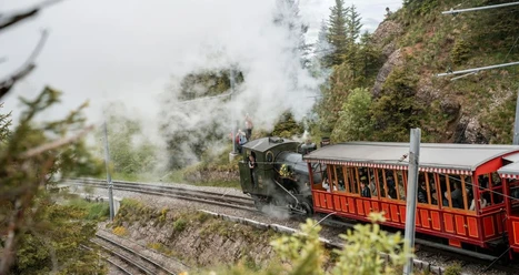
From the boat station, we walk along the lake, past the Rigi railways depot and then left to the main road. Now we follow the road briefly and then turn left through the small forest up to the Vitznau campsite. We cross the campsite and follow the road to its end. We keep left and continue walking up along the protective dam, reaching the Norli hunting lodge. Soon a small fire pit invites you to rest. Opposite is the climbing wall. The path leads us left back into the village and in a right curve, past the football field, we encounter the waterfall of the Mühlebach. Past the greenhouses, we reach the Plattenbänkli viewpoint. After crossing the cog railway track, the path steadily ascends along Wilenstrasse. We are rewarded with a beautiful view. After about 1.5 km, the path branches off to the left and we descend the mountain trail along the romantic brook bank down to the lakeshore. Now it’s all along the lake back to the village center of Vitznau.
Tour information
Loop Road
Author
Tourist Information Weggis (Luzern Tourismus AG)
Organization
Weggis Vitznau Rigi
Nearby


Download GPX file