Weggis - Räbalp/Seebodenalp circular hike


- 3:50 h
- 10.34 km
- 691 m
- 691 m
- 435 m
- 1,126 m
- 691 m
- Start: Weggis boat station
- Destination: Weggis boat station
The hike on the southwest slope of the Rigi leads to the edge of Seebodenalp and on to the Alpwirtschaft Räb.

Waypoints

Good to know
Pavements
Best to visit
Directions
The starting point is at the boat station in Weggis. From the village crossroads, follow Rigiblickstrasse (between the school and parish church) and Untereggistrasse straight ahead. At the farmhouse "Schlosshof" keep right; on the paved road, you pass more farms. After a few hairpin bends, you reach the charming house at Unterstutzberg. After crossing the meadow, you go through a short forest section. The path continues to rise until reaching a paved road. Cross this and continue uphill through the forest. Soon the Alpwirtschaft Räb comes into view. Your efforts are rewarded with a fantastic view of Lake Lucerne and the lowlands.
After a refreshment at Räbalp, the path leads along the Rigi slope to Bergli and Schlieriberg. The descent now becomes steeper – along a hedge – down to Tannenberg, Telli, and back to the village center of Weggis.
Tour information
Loop Road
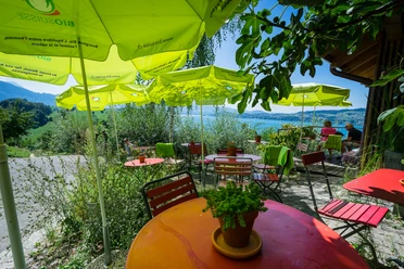
Stop at an Inn
Directions & Parking facilities
The "Dorf" car park is located on Rigistrasse, 200 meters from the lake. Price CHF 8.00 / day.
Author
Tourist Information Weggis (Luzern Tourismus AG)
Organization
Weggis Vitznau Rigi
Author´s Tip / Recommendation of the author
Nearby


Download GPX file